

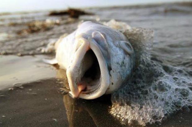
FWC Reports Offshore Red Tide, Mote Scientists Gear up to Learn More
![]()
Hayley Rutger / July, 2014
[dropcap]T[/dropcap]he Florida Fish and Wildlife Conservation Commission (FWC) reported last week that a bloom of Florida red tide was confirmed in water samples collected offshore of Hernando County, in the area of a large fish kill. Satellite images suggested the bloom was 80 miles long and 50 miles wide and was 40- 90 miles offshore between Dixie and Pasco counties.
NOTE: See the July 25 press release from FWC . . .
This week, scientists from Mote Marine Laboratory plan to learn more about the bloom and the physical conditions surrounding it by conducting a water sampling survey between Sarasota and the southern edge of the bloom.
Red tides in the Gulf of Mexico are a result of high concentrations of Karenia brevis, a microscopic marine algae that occurs naturally but normally in lower concentrations. In high concentrations, its toxin paralyzes the central nervous system of fish so they cannot breathe.
This effort is part of a cooperative research program between Mote — an independent nonprofit marine lab with decades of experience studying Florida red tide — and FWC — Florida’s wildlife agency responsible for monitoring and studying red tide blooms around the state.
Florida red tide is a higher-than-normal concentration of naturally occurring, harmful microscopic algae called Karenia brevis. These red tides are known to form many miles offshore, sometimes causing no impact to humans. In other cases they may be blown inshore and cause respiratory irritation among beachgoers. According to an update from the National Oceanic and Atmospheric Administration on Monday, July 28, the current bloom is NOT expected to cause respiratory irritation alongshore of southwest Florida through Monday, August 4.
Mote’s upcoming research:
Mote scientists plan to sample water Thursday, July 31, offshore of Sarasota, Clearwater and northwest approaching the last known edge of the bloom. Satellite images allow scientists to see algae blooms at the surface, but water samples are required to confirm the species of algae and to document the unique conditions surrounding each bloom.
Each bloom is a complex mix of biology, chemistry and physical conditions, and there is no single way that blooms form. Continued research is critical for understanding the formation and inner workings of blooms.Thursday, scientists in Mote’s Phytoplankton Ecology Program will document the presence and concentration of K. brevis cells, monitor physical conditions such as temperature, depth and salinity and examine how these characteristics are stratified, or layered from the surface down to depths of up to 100 feet.
Based on results from this trip, Mote’s Ocean Technology Program plans to deploy “Waldo,” an autonomous underwater vehicle (AUV), to sample for physical conditions and the presence of K. brevis using a red tide detector developed at Mote. The AUV will be deployed as close as possible to the bloom center and will be programmed to perform detailed and repeated surveys from surface to bottom as it progresses to the south. Survey results will provide data from depths not visible in satellite images. Physical data collected can be incorporated into models designed by other institutions to provide short term forecasts of the bloom’s trajectory. Another glider from University of South Florida will likely be deployed simultaneously to increase the region that can be surveyed.
Red tide resources:
Statewide red tide updates and info from FWC . . .
Statewide updates in the HAB Bulletin from NOAA . . .
Red tide information from Mote, including FAQs and the Beach Conditions Report – a monitoring system for red tide impacts on multiple Florida beaches . . .
[information] NOAA’s report forecast NO respiratory impacts to beachgoers through Monday, Aug. 4.
[/information]