by Jonathan Wright / October 24th, 2016 / Fly Fisherman Magazine
Are you adventurous? Learn to fly fish the entire stream system of the continental United States
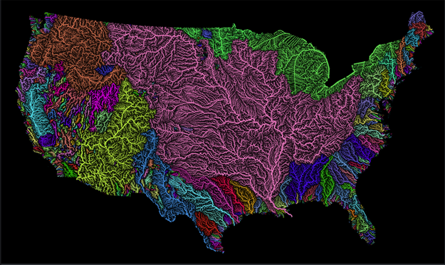
[dropcap]A[/dropcap]fantastic new US stream map of the entire stream system in the continental United States has been released on the web. Outside of its obvious artistic merit, the map should be an excellent resource for adventurous anglers and those seeking to better understand drainages and species distribution
The map, created by Imgur Fejetlenfej, a geographer and GIS analyst with a ‘lifelong passion for beautiful maps,’ highlights the massive expanse of river basins across the country – in particular, those that feed the Mississippi River.
As published by the London Daily Mail, the map was produced using open-source software from US Geological Survey data available online, with high-resolution prints being made available on the fine arts micro-retail site Etsy.
The Major U. S. River Basin System
There are 18 major river basins in the United States:
1.) Pacific Northwest Basin
2.) California River Basin
3.) Great Basin
4.) Lower Colorado River Basin
5.) Upper Colorado River Basin
6.) The Rio Grande River Basin
7.) Texas Gulf Coast Basin
8.) Arkansas-White-Red Basin
9.) Lower Mississippi River Basin
10.) Missouri River Basin
11.) Souris-Red-Rainy Basin
12.) Upper Mississippi Basin
13.) Great Lakes Basin
14.) Tennessee River Basin
15.) Ohio River Basin
16.) South Atlantic-Gulf Basin
17.) Mid-Atlantic Basin
18.) New England Basin
Read more at the Fly Fisherman here . . .
NOTE: Featured Image is a big baby tarpon caught in Indian River Lagoon, Florida, on February 9, 2016. Image credit Capt Tom Van Horn.


