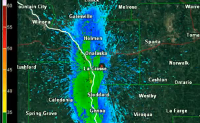
[dropcap]A[/dropcap] massive mayfly hatch on the Mississippi River in the La Crosse, Wisconsin area July 20, 2014, was described as a insect infestation of “biblical proportions” so intense that it made driving in the region difficult and even dangerous. Poor visibility and slippery roads (due to mayflies) were blamed for a three-vehicle accident on the Hwy. 63 bridge linking Red Wing and Hager City, Wisconsin, that left one person hospitalized.
The hatch captured on the National Weather Service’s (NWS) Doppler radar looks like a rain storm, but is actually a cloud of Hexagenia bilineata mayflies stretching from Redwing Minnesota in the north to to Prairie du Chien Wisconsin.
According to the NWS:
“The radar detected the flies about 8:45 pm, emanating from the river (the source) with echo values similar to that of light-moderate rain (35-40 dBZ). With a general south-to-north wind flow above the surface, the mayflies quickly moved north once in the air. As the flies dispersed moving north-northeast, they also gained altitude with some of the echo being detected as far north as Black River Falls and as high as 2,500 feet above ground.
“By late evening, mayflies were swarming in La Crosse, La Crescent, Stoddard and points up and down the river. While the emergence of mayflies from their river bottom mud dwelling can occur at various times through the warm season depending on the species, this particular emergence was that of the larger black/brown bilineata species. The radar loop shows the reflected radar energy (reflectivity) from 835 pm to just after midnight. The higher the values (greens to yellows) indicate greater concentrations of flies.”
[youtube id=”BkLV8zWiRVk” width=”620″ height=”360″]
Last year along the Mississippi, similar but less intense hatches of the same species occurred on June 15, 18 and 25, and on July 14.
June 23, 2012 was the last hatch of this size. That event was also termed “massive” by the NWS, and it too caused collisions and required snowplows for cleanup duty.
According to the NWS, the heavy hatches in recent years are the result of environmental protections that are resulting in cleaner water and better habitat for the burrowing mayflies.
SOURCE – multiple news outlets and Fly fisherman.


